A postcard of Regent's Park from the air, c.1921

In 2017, the Royal Parks Guild published a book, “The Royal Parks in the Great War – Revealing their Part in the Conflict”.

This postcard/aerial photograph from around 1921 shows a number of features in the park, some of which have changed of vanished in 100 years or so, including some WWI facilities.

In WWI, the park was heavily used for war related activities: for example, a sorting office for the Royal Engineers Postal Service (REPS), covering 4 acres, and known as the “Home Depot”, was erected on Cumberland Green in 1915.

This was soon found inadequate for the huge numbers of letters and parcels shipped to the troops by loving relatives – so the size was increased by a third.

That depot is out of shot in this aerial view, but a similarly large “temporary” storage facility for aircraft parts, constructed on Marylebone Green by the Royal Air Force , can clearly be seen in the image.

After the war, a private company operated out of these premises until 1924.(see No.1). Other numbered features of interest are described below.
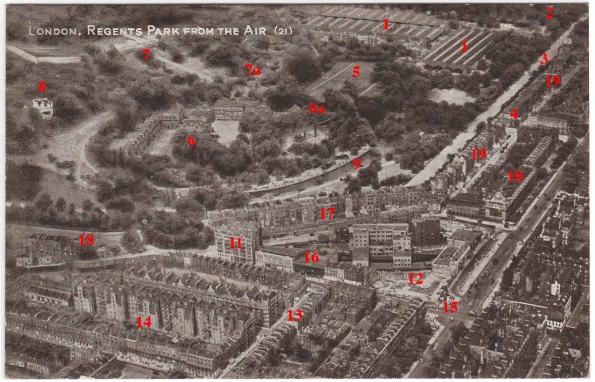
  • 1) The Aircraft Disposal Company buildings (demolished in 1924).
    These days Marylebone Green hosts rather different temporary structures erected annually for the Frieze Art Fair.

  • 2) The Broad Walk / Avenue Gardens.
    In origin an ancient boundary between the Manor of Tyburn and the Manors of Rugmere and Tottenham Courte. In 1921 it marked the boundary between the Boroughs of St Marylebone and St Pancras, Today, it separates Westminster from Camden.

  • 3) The Outer Circle.
    It owes its roughly round shape to the slightly larger circle drawn on a map by Henry
    VIII (or one of his henchmen) in the late 1530s when he created Marylebone Park, ignoring the niceties of any pre-existing land ownership.

  • 4) York Gate.
    John Nash wanted us to view the parish church between the unbroken façades of two palace-like buildings, so he put all the front doors to York Terrace in the mews at the back.

  • 5) Grounds of the Toxophilite (Archery) Society from 1832.
    Their lease ran out in 1922 and was not renewed. Tennis courts occupy this site today.

  • 6) Bedford College.
    By the time of this photo Decimus Burton’s South Villa had been rebuilt (1879-83) and extra buildings added in the style of a Cambridge college. The replacement villa (c.1778) by Horace Gundry, can just be seen behind the trees and above the no.6. In 1930 most of these buildings were demolished and replaced. The site is currently home of Regent’s University. The only vestige of Burton’s scheme is a hexagonal gate lodge (6a).

  • 7) At the time of this photo, the area inside the Inner Circle belonged to the Royal Botanic Society.
    Their iron and glass conservatory and other buildings can just be seen above the No. 7. The broad path which leads to them is the same one that bisects Queen Mary’s Gardens today. 7a marks the raised area landscaped by the Society using the earth excavated to form their own lake. The Society disbanded itself in 1932 when its lease was not renewed, at a time when more of the Royal Parks were opened to the Public. Now the Inner Circle contains Queen Mary’s Rose Gardens, the Open Air Theatre, and The Regent’s Bar
    & Kitchen.

  • 8) The Holme, designed by Decimus Burton (1818) as the family residence.
    Viewed from this side one can make out one of the additions made by the then owner, the theatre impresario, George Dance.

  • 9) Eastern arm of the lake in Regent’s Park.
    The lake was originally fed by the River Tyburn which was carried over the canal in an aqueduct. However, today the lake is fed by an artesian well within the park.

  • 10) Madame Tussaud’s, Marylebone Road. In 1925, shortly after this photo was taken, a fire ripped through the building, destroying a star attraction — Napoleon’s coach — which had been recovered following the battle of Waterloo.

  • 11) Chalfont Court(1913), built on the site of Sarah Siddons’s house on what was still “Upper Baker Street” at the date of the photo. Not until the 1930s were Upper Baker St, York Place and Baker St named and numbered as one street, thus creating the renowned No. 221. The lower-rise building on the right is an electricity substation (1904-5), built as part of the electrification of the underground. Its Queen Anne revival style belies its utilitarian contents.

  • 12) Chiltern Court under construction. It had been planned as a hotel before WWI but was finally completed as suites and a restaurant in 1929. The tall building behind that reaches down over the tracks, is Selbie House, developed from 1911 onwards, as the head offices of the Metropolitan Railway. It was built of reinforced concrete but has a splendid white faience façade, obliquely fronting onto Allsop Place, in a quasi- Classical style with railway motifs.

  • 13) The 20th century densification of Marylebone is well under way. On the left, Clarence Gate Gardens (1909), is already built. In just over a decade the terraced houses on the right would all be demolished to make way for Berkeley Court (1931) and Dorset House (1935).

  • 14) Chagford Street – where the first Bentley motor car was made 100 years ago, a couple of years prior to this photo.

  • 15) Two-way traffic in Baker Street. In the 1970s, Baker Street and Gloucester Place were made into a one-way traffic system with damaging consequences for the local area. It was finally restored to its original state around 2015. Plus ça change, plus c’est la même chose! Note the circular junction at Baker Street and the Marylebone Road, known as “Marylebone Circus”. This circle was lost during road widening for the Westway in the 1970s.

  • 16) The dark building next to the electricity substation (see no.11) was the Leslie Green Bakerloo line Station with its characteristic ox-blood tiles. Completed c.1906, it was used for only a few years before the main station was developed and extended, and it was demolished in 1964, although the lift shafts remain. An undistinguished office block replaced it, and is inhabited by a coffee shop and the Baskin Robbins ice cream shop at ground level.

  • 17) Cornwall Terrace, by Decimus Burton and John Nash, 1821-1823. In this photo, the original mews houses fronting on to Allsop Place are still extant. The entire terrace was squatted by hippie groups in 1975, and after they were evicted, it became the HQ of British Land. Refurbished as luxury residences in the 2000s.

  • 18) Clarence Terrace, by Decimus Burton. 1823 Heavily bombed in WWII, so everything except the main facades to the park are from the 1950s.

  • 19) York Terrace East c.1824-26, and York Terrace West, c.1822. By John Nash. York Terrace West was heavily damaged in WWII by the same cluster of bombs that took out part of Madame Tussauds and the East block of Chiltern Court. The Western End of Tussauds was rebuilt as a planetarium, and the distinctive 1950s dome remains today.


    Mike Wood, Cynthia Poole